

Route through Parque Rural de Anaga II
Life in harmony with nature
Presentation
On this route you will discover the northernmost part of the Parque Rural de Anaga. In it you will have the opportunity of discovering old hamlets, admiring spectacular views of the Atlantic Ocean and venturing into the forests, ravines
and valleys of the Anaga massif, and experience at first hand the history and traditions of this beautiful little corner of Tenerife.
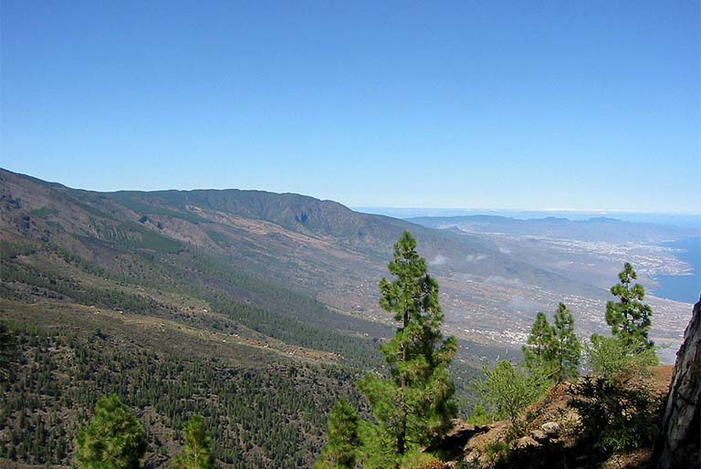
The Parque Rural de Anaga is a natural beauty spot located in the Anaga massif. The tremendous diversity of scenery which it displays, the result of its geographic relief and the variability of its climate, make Anaga a quite unique area.
The geological formations make the massif one of the Island’s most ancient, clearly reflected in its ravines, valleys and rock.
Its peculiar climate and relief have permitted the emergence of a rich and varied flora, among which the evergreen forests, the juniper woods such as that of Afur, the areas invaded by spurges, etc. are worthy of note.
This route leads you to the heart of Anaga, where in addition, you will be able to discover small farmsteads and villages which still retain the charm of times past. Thanks to these small settlements you will be able to get an insight into the traditional rural way of life of its inhabitants, get a notion of its customs and admire a landscape marked by small fields and humble country houses
Places of interest
ALMÁCIGA AND BENIJO
Location: Main road from El Bailadero to Benijo (by way of Taganana), TF-134.
PICO DEL INGLÉS VIEWPOINT
Location: Main road to the Pico del Inglés Viewpoint, TF-114
LA CRUZ DEL CARMEN
Location: Main road to the forest of Las Mercedes, km marker 6. San Cristóbal de La Laguna
Tfno.: 922 633 576
Route points
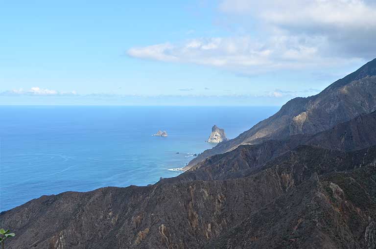
From the Amogoje Viewpoint you can contemplate the exceptional views of the Atlantic coast, of the valley of Taganana and of the rocky islets of Anaga.
The islets form part of the Roques de Anaga Nature Reserve. This nature site is formed by two rocks, the Roque de Tierra (landward rock), the larger of the two nearest to the coast, and the Roque de Fuera (outer rock). Their original shapes and their location, emerging as they do from the Atlantic, have made them a symbol of the Island.
This corner of Anaga, besides, is characterised by the singular lie of the land, formed by mountains with impossible contours, plunging valleys and craggy cliffs that paint a unique scenery of a beauty difficult to describe.

/
{"playlist":[{"title":"VILLAGE OF TIERRA DEL TRIGO","artist_name":"","audio_file":"https:\/\/rutasteneriferural.com\/wp-content\/uploads\/2022\/09\/02-village-of-tierra-del-trigo_MBaP.mp3","poster_image":"https:\/\/rutasteneriferural.com\/wp-content\/uploads\/2022\/07\/1Tierra-del-trigo3Reducida.jpg","duration":"0:30","playlistid":"playlistid-1"}]}
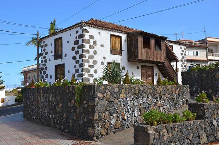
As its name implies, agriculture has played a major role in the life of this community. Located in the middle slopes at roughly 500 meters above sea level and surrounded by mountains, this tiny village retains all the charm of the world of the peasant farmer in the north of the Island. Cereals and other crops such as vines have traditionally been the economic livelihood of the population. Evidence of this is the existence of several wineries, all of which come under the aegis of the Ycoden-Daute-Isora Designation of Origin. It exhibits some examples of ordinary people's dwellings, with houses located near the cultivated plots, being mainly build of stone, wood and tiles. Tierra de Trigo is reached by a winding road with narrow bends, so cautious driving is a must. However, the journey has superb views of Los Silos, of Buenavista del Norte and of the village itself, which appears, almost by surprise, against the backdrop of the mountains.


/
{"playlist":[{"title":"LOMO MOLINO VIEWPOINT","artist_name":"","audio_file":"https:\/\/rutasteneriferural.com\/wp-content\/uploads\/2022\/09\/03-lomo-molino-viewpoint_5idh.mp3","poster_image":"https:\/\/rutasteneriferural.com\/wp-content\/uploads\/2022\/07\/1Mirador3Reducida.jpg","duration":"0:36","playlistid":"playlistid-2"}]}
This viewpoint, belonging to the Island Network of Viewpoints and recently reopened, offers breathtaking views of this area of northern Tenerife. Its privileged location gives it of some of the best views over the north of the Island. Seeing the sea and the beauty of the villages of northern Tenerife from here is an unforgettable experience. Furthermore, the viewpoint has a restaurant, cafe, souvenir shop and a car park.


/
{"playlist":[{"title":"TOWN CENTRE OF EL TANQUE","artist_name":"","audio_file":"https:\/\/rutasteneriferural.com\/wp-content\/uploads\/2022\/09\/04-town-centre-of-el-tanque_aNaz.mp3","poster_image":"https:\/\/rutasteneriferural.com\/wp-content\/uploads\/2022\/07\/0El-Tanque-1Reducida.jpg","duration":"0:34","playlistid":"playlistid-3"}]}
The village of El Tanque is located on the upper slopes of the north of Tenerife. During the visit you will get to know a town markedly agricultural in nature, where some parts of the small-farming tradition still survive in northern Tenerife with cultivated plots and traditional buildings. A feature of its urban landscape, where the church and the present town hall stand out, is the alternating mixture of buildings and farmland. The visit is also an inviting opportunity to learn about the rich cuisine of the area, where you can taste some of the most typical dishes of Canarian food such as the puchero [stew].


/
{"playlist":[{"title":"ERJOS AND CHARCAS DE ERJOS","artist_name":"","audio_file":"https:\/\/rutasteneriferural.com\/wp-content\/uploads\/2022\/09\/05-erjos-and-charcas-de-erjos_1dAm.mp3","poster_image":"https:\/\/rutasteneriferural.com\/wp-content\/uploads\/2022\/07\/0Charca1Reducida.jpg","duration":"1:09","playlistid":"playlistid-4"}]}
In the upper region of Los Silos and El Tanque stands the village of Erjos. Nestling in a singular natural environment, visitors discover not only part of the very essence of these rural landscapes of northern Tenerife, but the beauty of the natural surroundings where it is situated. Its past, traditionally agricultural, remains alive today in cultivated plots and farmland. Although the current trend is towards the decline of agriculture in favour of other activities and despite rural depopulation and emigration, in Erjos there still exist many examples of the farming way of life. The village has traditional houses, some very old, some of more recent construction. Also, another major attraction of Erjos is the richness of its surrounding landscapes. Besides the beautiful rural scene that the village represents, in the upper part there are what are known as the "Erjos ponds”. The ponds were formed as a result of gravel and earth being extracted from the area during the last decades of the XXth century and intended for plantations in the south of the Island. The resulting pits have become filled with rainwater due to the clayey nature of the soil and allowed the creation of an entire original ecosystem around them.


