

Route Los Realejos
History, nature and agriculture
Presentation
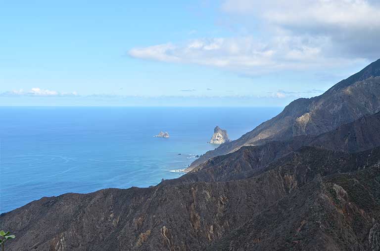
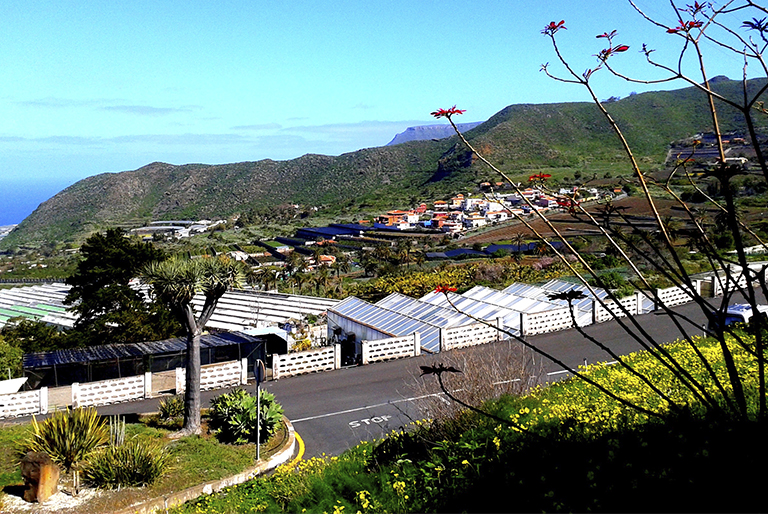
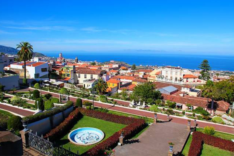
On this route you enter the heart of the northern municipality of Los Realejos, situated in the Orotava Valley, in a unique location and which features leafy, varied vegetation and more than five centuries of history. The roots of Los Realejos go back to pre-hispanic times, when these lands belonged to the aboriginal kingdom of Taoro. According to the tradition, this was the scene of great historical events; this is where the guanches surrendered to the Castilian conquerors and is thus the place where the Island became part of the Realm of Castille. Here the victors established one of the first settlements on the Island and in the area of Upper Realejo (Realejo Alto) they built the first religious shrine on Tenerife, the Church of Santiago Apóstol (the apostle James). Apparently this is where the guanche kings received the sacrament of baptism together with other aborigines in the year 1498. The village was devoted mainly to agriculture and, to a lesser extent, to cattle farming. Reflecting this is the installation after the conquest of a sugar mill on Los Príncipes estate in Realejo Bajo (Lower Realejo), owned by one of the conquerors, Alonso Fernández de Lugo, and which is said to have stood in the so-called King’s Field, the name by which the fertile territories belonging to the Mencey (guanche king) Bencomo were known. You will discover small villages that retain all the essence of times past, such as Realejo Bajo, which has a well-preserved collection of beautiful, historical buildings which has earned it the status of a Site of Cultural Interest. On the route you will see different estates and religious buildings, reflecting earlier periods of splendour, a consequence of the economic power which grew as traders settled and different religious orders became established. However, the development of the town itself and new town planning requirements have meant that much of this heritage has remained scattered among new buildings that have sprung up. As a result, Los Realejos does not have a well-defined and preserved historical centre, except for Realejo Bajo. Los Realejos is the birthplace of the famous writer, biologist and historian José de Viera y Clavijo. His birthplace can be found in Realejo Alto (Upper Realejo), on the street that bears his name, at No. 101. This is a two-story house which retains only the original facade as its interior has been completely altered according to the needs of its inhabitants. The municipality is also of great natural and scenic interest with many protected natural areas like Los Campeches, Tigaiga y Ruiz, the Rambla de Castro, the Natural Monument of Los Frailes Mountain and the Barranco de Ruiz (ravine), a Site of Scientific Interest, perfect for taking part in activities in nature, such as hiking. The many viewpoints provided also bring us closer to this reality, offering views of the Orotava Valley and allowing visitors to discover amazing panoramic views of the town, observing its urban growth with historic buildings and a green, rugged landscape with a steep coast consisting of cliffs and deep gorges that scar the territory from the mountains to the sea.
Places of interest
RECREATIONAL AREA OF CHANAJIGA
Location: On the main road La Orotava-Palo Blanco-Benijos: signpost on the left-hand side; or on the main TF-821, La Orotava-Las Cañadas, turn-off on the right-hand side along a forest track.
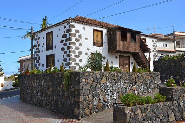
REALEJO ALTO
Location: Carretera TF-334, Realejo Alto. Los Realejos.
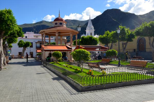
MARKET OF LOS REALEJOS
Location: Plaza Viera y Clavijo, Realejo Alto. Los Realejos.
Opening times: Saturdays and Sundays 9:00-14:00
Route points
/
{"playlist":[{"title":"RAMBLA DE CASTRO","artist_name":"","audio_file":"https:\/\/rutasteneriferural.com\/wp-content\/uploads\/2022\/09\/01-rambla-de-castro_qGE4.mp3","poster_image":"https:\/\/rutasteneriferural.com\/wp-content\/uploads\/2022\/07\/1Rambla-de-Castro2Reducida.jpg","duration":"1:11","playlistid":"playlistid-1"}]}
The Rambla de Castro is a natural site of great scenic value. Nestling in the coastal strip of the municipality of Los Realejos, it covers 45.9 hectares and gives beautiful panoramic views along the north coast of Tenerife. This green beauty spot situated on the shore of the Atlantic is surrounded by a great variety of flora such as palm trees, dragon trees and bananas. It contains a number of exceptional, characteristic buildings such as the Hacienda de Castro whose origins go back to the XVIth century, although in fact the present building is from the XVIIIth century; the Fortín de San Fernando (fort), that served to fend off attacks by pirates; the Gordejuela building, which housed the first steam engine on the Island, and the chapel of San Pedro. A visit to this area gives the visitor a range of choices. First of all, the Rambla de Castro forms part of the “Sendero del Agua” (coastal path) which starts from the Hotel Marítim (in Los Realejos), crosses the Los Roques beach, La Romántica residential estate, the Rambla de Castro and finishes at the San Pedro viewpoint. Walking the whole path allows you to enjoy a pleasant excursion and discover this delightful spot on Tenerife's north coast. You can also access the Rambla from the San Pedro viewpoint and take a stroll through it, visiting its most characteristic buildings and open spaces and take in the spectacular views of the Atlantic from the viewpoint.


/
{"playlist":[{"title":"REALEJO BAJO","artist_name":"","audio_file":"https:\/\/rutasteneriferural.com\/wp-content\/uploads\/2022\/09\/02-realejo-bajo_4MKg.mp3","poster_image":"https:\/\/rutasteneriferural.com\/wp-content\/uploads\/2022\/08\/0Realejo-Bajo1Reducida.jpg","duration":"1:31","playlistid":"playlistid-2"}]}
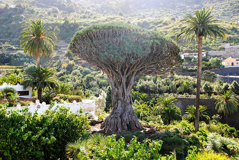
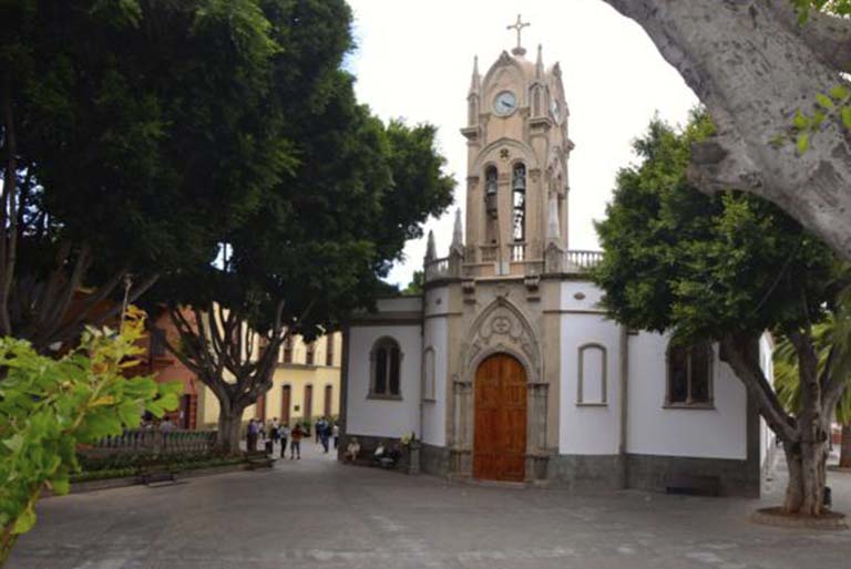
Lower Realejo is an urban area that until the mid-twentieth century was an independent town. It is a town steeped in history, where the Adelantado (*) Alonso Fernández de Lugo founded an estate and a sugar mill in the area called the Hacienda de Los Príncipes. The town's origins are linked to this estate, for its gradual development was accompanied by the arrival of new settlers who chose to build their homes nearby on land donated by the Adelantado allowing the formation of the original town. Traditionally it has been devoted to agriculture, much of its land being used for growing sugar cane, vines, etc. It has preserved an interesting collection of historical buildings, declared a Site of Cultural Interest, where you can see different buildings of particular architectural significance. Outstanding among them is the Church of the Concepción whose origins date back to the sixteenth century when a small chapel was built. The present church dates from the late XVIth and early XVIIth centuries and suffered a devastating fire in 1978 from which only a few religious images, such as the Lady of the Rosary, and various pieces of precious metal work were able to be saved. Laborious reconstruction work is being carried out to restore all its splendour and beauty. The steps of Domínguez Afonso Square, where the church is situated, has two magnificent specimens of ancient dragon trees, known as the Dragos Gemelos (twin dragon trees). Next to the square an information panel gives suggestions for an interesting tour of the town. It recommends a visit to the old Town Hall, various properties located in Acequia Street, the Hacienda de Los Príncipes (estate) and the chapel of San Sebastián. We recommend a stroll through the streets, savouring the historical and artistic wealth of the place and discovering the friendliness of the residents at first hand. This is certainly a special place that exists in perfect harmony with modern times without losing touch with the traditions and customs of northern Tenerife. The magnificent estate, the Hacienda de Los Príncipes, deserves a special mention; its name refers to the Princes of Asculi, its owners during a certain period, descendants of Alonso Fernández de Lugo. The chapel of San Sebastian forms part of the cluster of historical buildings. It was built in the early XVIIIth century, but was destroyed by fire in 1886. Today the hacienda only retains some of its structural elements and parts of the old mills. The current building has an L-shaped floor plan and dates from the XVIIth and XVIIIth centuries. * Adelantado: a title granted by the King to the nobles who administered newly conquered territory


/
{"playlist":[{"title":"TIGAIGA","artist_name":"","audio_file":"https:\/\/rutasteneriferural.com\/wp-content\/uploads\/2022\/09\/03-tigaiga_dqA4.mp3","poster_image":"https:\/\/rutasteneriferural.com\/wp-content\/uploads\/2022\/07\/0Tigaiga1Reducida.jpg","duration":"0:54","playlistid":"playlistid-3"}]}
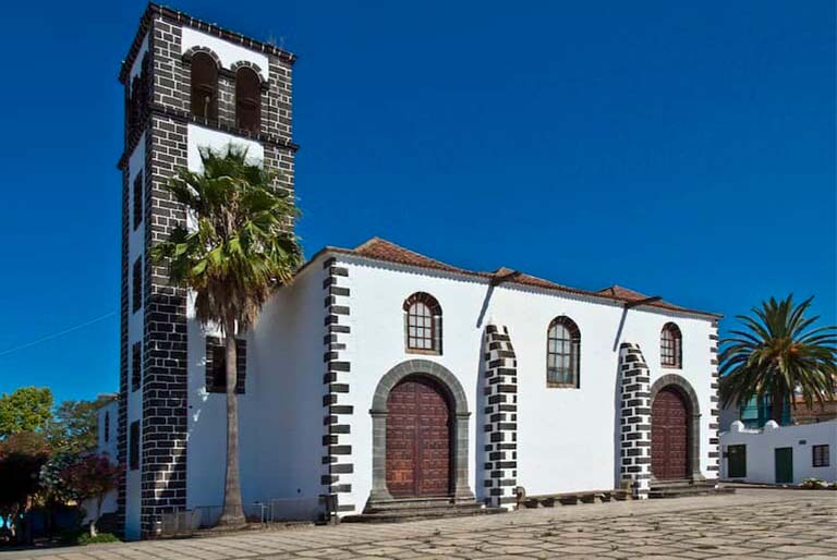
In Tigagiga, the neighbourhood at the foot of the steep mountain of the same name, you can become acquainted with all the charm of small towns in the north of Tenerife. The town is known for its peace and quiet which give it a special charm and make it the perfect place to relax and unwind. Its origins go back to the XVIth century, one of the most important historical sites in the municipality of Los Realejos. Traditionally devoted to agriculture, in the village some notable estates were established, among which the most outstanding are the Hacienda de La Fuente, which houses a public clothes washing place, the Hacienda de La Era and La Coronela. At the heart of the village stands the small church of Nuestra Señora de La Concepción, from whose square you can see a wonderful panorama. Around the church you will find a number of homes which feature a curious decoration of their facades, in some cases, drawings done with vivid colours. While there are now various buildings of more recent construction that have transformed its traditional appearance, the town continues to maintain the essence of the rural world.


/
{"playlist":[{"title":"MIRADOR DE EL LANCE (VIEWPOINT)","artist_name":"","audio_file":"https:\/\/rutasteneriferural.com\/wp-content\/uploads\/2022\/09\/04-mirador-de-el-lance_D2sl.mp3","poster_image":"https:\/\/rutasteneriferural.com\/wp-content\/uploads\/2022\/07\/0Mirador-de-El-Lance1Reducida.jpg","duration":"0:34","playlistid":"playlistid-4"}]}
The El Lance viewpoint is located on the cliff of Tigaiga. Even the road to reach it offers spectacular views, an authentic sample of the rich landscape of this corner of the Island. The viewpoint pays tribute to one of the best known historical episodes in the area. Tradition has it that the Mencey Bentor leapt into the void from this very spot, preferring death rather than surrender to the Castilian armies. A statue of the mencey commemorates this event. Nowadays this viewpoint offers a landscape of great beauty from which to survey spectacular views of the Orotava Valley. Its location makes it a valuable lookout point, allowing you to perceive the main features of where the population of the area is concentrated, marking the various urban areas and outlining all the northern coast of Tenerife. The viewpoint cafe and restaurant are also worth a visit.


/
{"playlist":[{"title":"MIRADOR DE LA CORONA (VIEWPOINT)","artist_name":"","audio_file":"https:\/\/rutasteneriferural.com\/wp-content\/uploads\/2022\/09\/05-mirador-de-la-corona_DejT.mp3","poster_image":"https:\/\/rutasteneriferural.com\/wp-content\/uploads\/2022\/07\/0Mirador-de-La-Corona1Reducida.jpg","duration":"0:45","playlistid":"playlistid-5"}]}
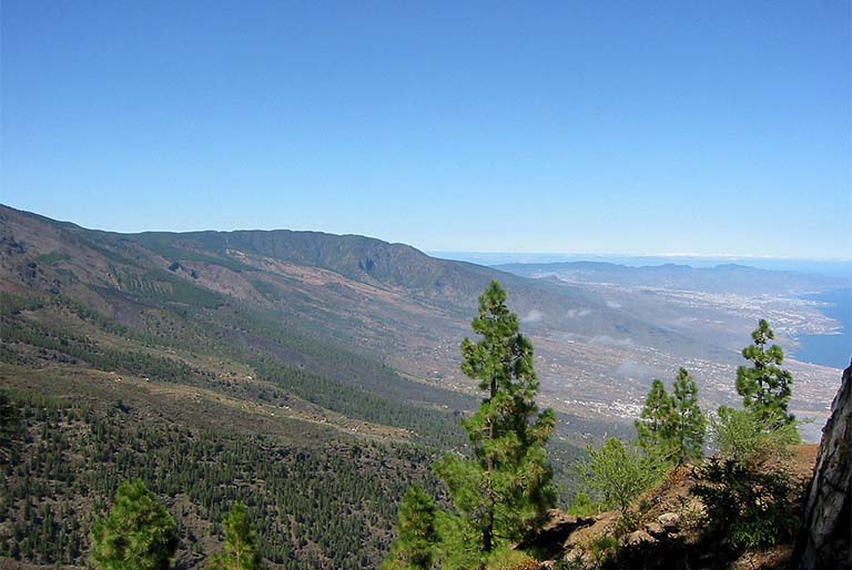
The La Corona viewpoint is located at a considerable height above sea-level, some 780 metres, and offers breathtaking views of the entire municipality of Los Realejos. Access to it and its location give it a special value, as it permits you to see in detail the agricultural areas of the municipality's upper reaches. To get there you have to cross Icod El Alto and its higher ground, entering the Protected Landscape of Los Campeches. It is characterized by a rural landscape, consisting of widely-scattered, traditional houses and numerous farm plots, many abandoned, which in their day were filled with potatoes and cereals. In addition the viewpoint offers a wonderful panorama made up of a green backdrop, dotted with numerous villages and marked by an original topography, of great landscape value. It has tables and a roofed memorial cross, next to a ramp for paragliders to take off.


